
TOPKAPI


TOPKAPI (TOPographic Kinematic APproximation and Integration) model is a fully-distributed physically-based hydrological model that can provide high resolution information on the hydrological state of a catchment.
The model can be used both as a stand-alone program and inside real-time operational flood forecasting systems.
Fields of application include:
- Catchment hydrology
- Flood forecasting
- Water resources management
- Artificial reservoirs management
- Land use and climate change
- Irrigation and drought
- Landslides
|
VIDEO: |
BROCHURE: | TECHNICAL DOCUMENTATION: | PURCHASE: |
|
|
|
|
MODEL FEATURES
COMPUTATIONAL MODULES
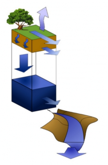
TOPKAPI reproduces the behaviour of the main components of the hydrologic cycle:
- subsurface flow
- overland flow
- channel flow (kinematic and parabolic)
- infiltration
- percolation
- evapo-transpiration
- snowmelt
A lake/reservoir component and a parabolic routing component based on Muskingum-Cunge method are also available.
Each computational component can be activated separately.
ADVANTAGES
Using TOPKAPI model you can:
- Have reduced execution times suitable for distributed model calibrations and real-time operational applications.
- Easily calibrate you model due to physically meaningful parameters whose values can be retrieved from Digital elevation maps, soil maps, land use and vegetation maps.
- Track the spatial variability of runoff conditions in the catchment getting flow predictions at any point of the channel network.
- Fully exploit spatial variability in precipitation estimates from RADAR networks.
- Resolve basin hydrologic response at very fine temporal (few minutes) and spatial (100-1000 m) scales in both small and large catchments.
- Run the model at different time scales, up to daily simulations.
- Run event based and continuous simulations (climatological studies).
MODEL RESULTS
Model results include:
- Water balance at catchment and sub-catchment scale for main hydrologic quantities
- Time series (1D) of hydrologic quantities at catchment and sub-catchment scale, such as precipitation, air temperature, evapo-transpiration, snow accumulation and snowmelt, percolation, surface flow, channel flow, ect. Time series are available for every cell of the model, i.e. on the entire catchment.
- State maps (2D) of the catchment referring to the main hydrologic quantities, such as soil moisture, evapo-transpiration, river flow, ect. State maps provided by TOPKAPI model can be used to monitor the behavior of the catchment during severe hydro-meteorological events and can be used for landslide monitoring, fire prevention and water resources applications.